
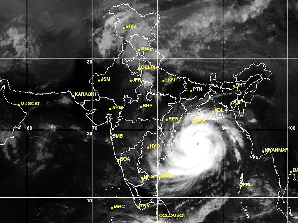
Satellite imagery has provided a striking view of Cyclone Arnab’s expansive reach even after the system made landfall and began to weaken. Although the storm has lost much of its original intensity, its sprawling cloud bands continue to influence weather patterns across large sections of the Indian subcontinent, carrying the potential for heavy rainfall in multiple states.
Landfall and Immediate Aftermath
Cyclone Arnab crossed the Andhra Pradesh and Yanam coasts as a very severe cyclonic storm between roughly 2 am and 8 am IST on 28 October. The centre passed near Narsapur in West Godavari district, with maximum sustained winds of 125 to 135 kmph and gusts reaching 150 kmph. Once the central region moved fully inland, the system began a steady process of weakening while continuing to draw moisture inland.
India’s INSAT-3DS weather satellite captured detailed thermal infrared imagery shortly after landfall. These images revealed dense cloud bands spiralling outward from the storm’s core and extending across significant portions of eastern and southern India as well as the Bay of Bengal. The scale of the cloud shield illustrated how a cyclone’s influence can persist well beyond the moment its centre crosses the coastline.
From Very Severe Cyclonic Storm to Depression
Following landfall, Arnab weakened progressively. It first became a severe cyclonic storm, then a cyclonic storm, and subsequently a deep depression. By the morning of 29 October, the India Meteorological Department reported that the deep depression had further weakened into a depression. At that time the system was centred over south Chhattisgarh and adjoining south Odisha, moving nearly northwards at approximately 22 kmph.
The depression was located roughly 20 km west of Jagdalpur in Chhattisgarh. Meteorologists expected it to continue its northward track and weaken into a well-marked low-pressure area by the evening of 29 October. Doppler weather radars at Raipur and Sambalpur maintained continuous surveillance of the system as it moved inland.
Satellite View of the Expanding Cloud Shield
The latest satellite images show a broad mass of clouds stretching from eastern and central India towards northern parts of the country. Bright cloud clusters visible in the imagery indicate regions of extensive cloud cover and areas of potential deep convection. As the remnant circulation advances, it continues to transport moisture, sustaining rainfall over locations far removed from the original landfall zone.
The imagery also reveals a separate cloud system over the Andaman Sea linked to a low-pressure area, underscoring concurrent weather activity over the eastern Indian Ocean. Together, these features demonstrate the complex atmospheric environment surrounding the remnants of Arnab.
Rainfall Risks Across Multiple States
Although the storm has lost its cyclonic intensity, the associated moisture and residual circulation pose continued heavy rainfall threats. Coastal and interior districts of Andhra Pradesh, parts of Odisha, Chhattisgarh, Jharkhand and Bihar remain under watch for heavy to very heavy rain at isolated places. Light to moderate rainfall with isolated heavier spells is also possible over sections of Gangetic West Bengal and neighbouring areas.
Localised flooding, waterlogging and disruptions to transport remain concerns in regions receiving intense showers. Authorities continue to monitor river levels and low-lying areas as the system tracks northward and gradually dissipates.
Broader Meteorological Significance
The satellite perspective of Arnab highlights an important characteristic of tropical cyclones that make landfall along India’s east coast. Even after the centre moves inland and winds decrease, the expansive cloud canopy and residual moisture can sustain unsettled weather for several days across a wide geographical domain. The images captured by INSAT-3DS offer a clear visual record of this process, showing how cloud bands that once organised around a powerful storm centre spread and influence distant regions.
Continuous radar and satellite monitoring has enabled timely updates on the system’s position, intensity and expected path. This real-time observation supports preparedness measures in states lying along the remnant track.
Looking Ahead
As the depression continues its northward movement and weakens further into a low-pressure area, rainfall intensity is expected to ease gradually. However, isolated heavy spells may persist in pockets for another day or two. Residents in affected regions are advised to remain attentive to official weather bulletins and local advisories.
The satellite record of Cyclone Arnab serves as a vivid illustration of both the power of these systems at landfall and the lingering atmospheric effects that follow. While the storm itself has largely run its course, its cloud shield continues to shape weather across a substantial portion of India, underscoring the value of space-based observation in tracking the full lifecycle of such events.
Read more – Aeshikshakosh.com